編輯:關於Android編程
	// 以下主要是定位用到的代碼
	private MapView mMapView;
	private BaiduMap mMapLayer;
	private LocationClient mLocClient;
	private boolean isFirstLoc = true;// 是否首次定位

	private void initLocation() {
		mMapView = (MapView) findViewById(R.id.bmapView);
		// 先隱藏地圖,待定位到當前城市時再顯示
		mMapView.setVisibility(View.INVISIBLE);
		mMapLayer = mMapView.getMap();
		mMapLayer.setOnMapClickListener(this);
		// 開啟定位圖層
		mMapLayer.setMyLocationEnabled(true);
		mLocClient = new LocationClient(this);
		// 設置定位監聽器
		mLocClient.registerLocationListener(new MyLocationListenner());
		LocationClientOption option = new LocationClientOption();
		option.setOpenGps(true);// 打開gps
		option.setCoorType("bd09ll"); // 設置坐標類型
		option.setScanSpan(1000);
		option.setIsNeedAddress(true); // 設置true才能獲得詳細的地址信息
		// 設置定位參數
		mLocClient.setLocOption(option);
		// 開始定位
		mLocClient.start();
		 //獲取最近一次的位置
		// mLocClient.getLastKnownLocation();
	}

	public class MyLocationListenner implements BDLocationListener {

		@Override
		public void onReceiveLocation(BDLocation location) {
			// map view 銷毀後不在處理新接收的位置
			if (location == null || mMapView == null) {
				Log.d(TAG, "location is null or mMapView is null");
				return;
			}
			m_latitude = location.getLatitude();
			m_longitude = location.getLongitude();
			String position = String.format("當前位置:%s|%s|%s|%s|%s|%s|%s",
					location.getProvince(), location.getCity(),
					location.getDistrict(), location.getStreet(),
					location.getStreetNumber(), location.getAddrStr(),
					location.getTime());
			loc_position.setText(position);
			MyLocationData locData = new MyLocationData.Builder()
					.accuracy(location.getRadius())
					// 此處設置開發者獲取到的方向信息,順時針0-360
					.direction(100).latitude(m_latitude)
					.longitude(m_longitude).build();
			mMapLayer.setMyLocationData(locData);
			if (isFirstLoc) {
				isFirstLoc = false;
				LatLng ll = new LatLng(m_latitude, m_longitude);
				MapStatusUpdate update = MapStatusUpdateFactory.newLatLngZoom(ll, 14);
				mMapLayer.animateMapStatus(update);
				// 定位到當前城市時再顯示圖層
				mMapView.setVisibility(View.VISIBLE);
			}
		}

		public void onReceivePoi(BDLocation poiLocation) {
		}
	}
	// 以下主要是定位用到的代碼
	private MapView mMapView;
	private AMap mMapLayer;
	private AMapLocationClient mLocClient;
	private boolean isFirstLoc = true;// 是否首次定位

	private void initLocation(Bundle savedInstanceState) {
		mMapView = (MapView) findViewById(R.id.amapView);
		mMapView.onCreate(savedInstanceState);
		// 先隱藏地圖,待定位到當前城市時再顯示
		mMapView.setVisibility(View.INVISIBLE);
		if (mMapLayer == null) {
			mMapLayer = mMapView.getMap();
		}
		mMapLayer.setOnMapClickListener(this);
		// 開啟定位圖層
		mMapLayer.setMyLocationEnabled(true);
		mMapLayer.setMyLocationType(AMap.LOCATION_TYPE_LOCATE);
		mLocClient = new AMapLocationClient(this.getApplicationContext());
		// 設置定位監聽器
		mLocClient.setLocationListener(new MyLocationListenner());
		AMapLocationClientOption option = new AMapLocationClientOption();
		option.setLocationMode(AMapLocationMode.Battery_Saving);
		option.setNeedAddress(true); // 設置true才能獲得詳細的地址信息
		// 設置定位參數
		mLocClient.setLocationOption(option);
		// 開始定位
		mLocClient.startLocation();
		 //獲取最近一次的位置
		// mLocClient.getLastKnownLocation();
	}

	public class MyLocationListenner implements AMapLocationListener {

		@Override
		public void onLocationChanged(AMapLocation location) {
			// map view 銷毀後不在處理新接收的位置
			if (location == null || mMapView == null) {
				Log.d(TAG, "location is null or mMapView is null");
				return;
			}
			m_latitude = location.getLatitude();
			m_longitude = location.getLongitude();
			String position = String.format("當前位置:%s|%s|%s|%s|%s|%s|%s",
					location.getProvince(), location.getCity(),
					location.getDistrict(), location.getStreet(),
					location.getAdCode(), location.getAddress(),
					location.getTime());
			loc_position.setText(position);
			if (isFirstLoc) {
				isFirstLoc = false;
				LatLng ll = new LatLng(m_latitude, m_longitude);
                CameraUpdate update = CameraUpdateFactory.newLatLngZoom(ll, 12);
				mMapLayer.moveCamera(update);
				// 定位到當前城市時再顯示圖層
				mMapView.setVisibility(View.VISIBLE);
			}
		}
	}
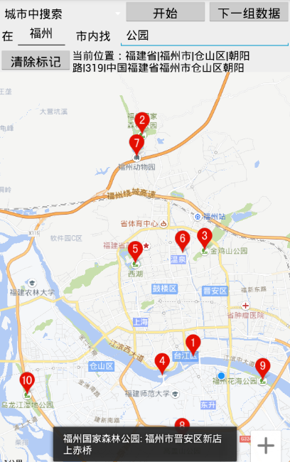
// 以下主要是POI搜索用到的代碼 private PoiSearch mPoiSearch = null; private SuggestionSearch mSuggestionSearch = null; private AutoCompleteTextView mKey = null; private EditText mScope = null; private Button btn_search, btn_nextpage, btn_cleardata; private ArrayAdaptersugAdapter = null; private int load_Index = 0; private void initMap() { mPoiSearch = PoiSearch.newInstance(); mPoiSearch.setOnGetPoiSearchResultListener(this); mSuggestionSearch = SuggestionSearch.newInstance(); mSuggestionSearch.setOnGetSuggestionResultListener(this); mScope = (EditText) findViewById(R.id.poi_city); mKey = (AutoCompleteTextView) findViewById(R.id.poi_searchkey); btn_search = (Button) findViewById(R.id.search); btn_nextpage = (Button) findViewById(R.id.map_next_data); btn_cleardata = (Button) findViewById(R.id.map_clear_data); btn_search.setOnClickListener(this); btn_nextpage.setOnClickListener(this); btn_cleardata.setOnClickListener(this); sugAdapter = new ArrayAdapter (this, R.layout.spinner_dropdown_item); mKey.setAdapter(sugAdapter); // 當輸入關鍵字變化時,動態更新建議列表 mKey.addTextChangedListener(new TextWatcher() { @Override public void afterTextChanged(Editable arg0) { } @Override public void beforeTextChanged(CharSequence arg0, int arg1, int arg2, int arg3) { } @Override public void onTextChanged(CharSequence cs, int arg1, int arg2, int arg3) { if (cs.length() <= 0) { return; } String city = mScope.getText().toString(); // 使用建議搜索服務獲取建議列表,結果在onGetSuggestionResult中更新 mSuggestionSearch .requestSuggestion((new SuggestionSearchOption()) .keyword(cs.toString()).city(city)); } }); } @Override public void onGetSuggestionResult(SuggestionResult res) { if (res == null || res.getAllSuggestions() == null) { return; } else { sugAdapter.clear(); for (SuggestionResult.SuggestionInfo info : res.getAllSuggestions()) { if (info.key != null) { sugAdapter.add(info.key); } } sugAdapter.notifyDataSetChanged(); } } // 影響搜索按鈕點擊事件 public void searchButtonProcess(View v) { Log.d(TAG, "editCity=" + mScope.getText().toString() + ", editSearchKey=" + mKey.getText().toString() + ", load_Index=" + load_Index); String keyword = mKey.getText().toString(); if (search_method == SEARCH_CITY) { String city = mScope.getText().toString(); mPoiSearch.searchInCity((new PoiCitySearchOption()).city(city) .keyword(keyword).pageNum(load_Index)); } else if (search_method == SEARCH_NEARBY) { LatLng position = new LatLng(m_latitude, m_longitude); int radius = Integer.parseInt(mScope.getText().toString()); mPoiSearch.searchNearby((new PoiNearbySearchOption()) .location(position).keyword(keyword).radius(radius) .pageNum(load_Index)); } } public void goToNextPage(View v) { load_Index++; searchButtonProcess(null); } public void onGetPoiResult(PoiResult result) { if (result == null || result.error == SearchResult.ERRORNO.RESULT_NOT_FOUND) { Toast.makeText(this, "未找到結果", Toast.LENGTH_LONG).show(); return; } else if (result.error == SearchResult.ERRORNO.NO_ERROR) { mMapLayer.clear(); PoiOverlay overlay = new MyPoiOverlay(mMapLayer); mMapLayer.setOnMarkerClickListener(overlay); List poiList = result.getAllPoi(); overlay.setData(result); overlay.addToMap(); overlay.zoomToSpan(); // for (PoiInfo poi : poiList) { // String detail = String.format( // "uid=%s,city=%s,name=%s,phone=%s, address=%s", poi.uid, // poi.city, poi.name, poi.phoneNum, poi.address); // Log.d(TAG, detail); // 坐標為poi.location(LatLng結構) // } } else if (result.error == SearchResult.ERRORNO.AMBIGUOUS_KEYWORD) { // 當輸入關鍵字在本市沒有找到,但在其他城市找到時,返回包含該關鍵字信息的城市列表 String strInfo = "在"; for (CityInfo cityInfo : result.getSuggestCityList()) { strInfo += cityInfo.city + ","; } strInfo += "找到結果"; Toast.makeText(this, strInfo, Toast.LENGTH_LONG).show(); } } public void onGetPoiDetailResult(PoiDetailResult result) { if (result.error != SearchResult.ERRORNO.NO_ERROR) { Toast.makeText(this, "抱歉,未找到結果", Toast.LENGTH_SHORT).show(); } else { Log.d(TAG, "name=" + result.getName() + ",address=" + result.getAddress() + ",detail_url=" + result.getDetailUrl() + ",shop_hours=" + result.getShopHours() + ",telephone=" + result.getTelephone() + ",price=" + result.getPrice() + ",type=" + result.getType() + ",tag=" + result.getTag()); Toast.makeText(this, result.getName() + ": " + result.getAddress(), Toast.LENGTH_SHORT).show(); } } private class MyPoiOverlay extends PoiOverlay { public MyPoiOverlay(BaiduMap baiduMap) { super(baiduMap); } @Override public boolean onPoiClick(int index) { super.onPoiClick(index); PoiInfo poi = getPoiResult().getAllPoi().get(index); mPoiSearch.searchPoiDetail((new PoiDetailSearchOption()).poiUid(poi.uid)); return true; } }
// 以下主要是POI搜索用到的代碼 private PoiSearch mPoiSearch = null; private AutoCompleteTextView mKey = null; private EditText mScope = null; private Button btn_search, btn_nextpage, btn_cleardata; private ArrayAdaptersugAdapter = null; private int load_Index = 0; private void initMap() { mScope = (EditText) findViewById(R.id.poi_city); mKey = (AutoCompleteTextView) findViewById(R.id.poi_searchkey); btn_search = (Button) findViewById(R.id.search); btn_nextpage = (Button) findViewById(R.id.map_next_data); btn_cleardata = (Button) findViewById(R.id.map_clear_data); btn_search.setOnClickListener(this); btn_nextpage.setOnClickListener(this); btn_cleardata.setOnClickListener(this); sugAdapter = new ArrayAdapter (this, R.layout.spinner_dropdown_item); mKey.setAdapter(sugAdapter); // 當輸入關鍵字變化時,動態更新建議列表 mKey.addTextChangedListener(new TextWatcher() { @Override public void afterTextChanged(Editable arg0) { } @Override public void beforeTextChanged(CharSequence arg0, int arg1, int arg2, int arg3) { } @Override public void onTextChanged(CharSequence cs, int arg1, int arg2, int arg3) { if (cs.length() <= 0) { return; } String city = mScope.getText().toString(); // 使用建議搜索服務獲取建議列表,結果在onGetInputtips中更新 InputtipsQuery inputquery = new InputtipsQuery(cs.toString(), city); Inputtips inputTips = new Inputtips(GaodeActivity.this, inputquery); inputTips.setInputtipsListener(GaodeActivity.this); inputTips.requestInputtipsAsyn(); } }); } @Override public void onGetInputtips(List tipList, int rCode) { if (rCode != 1000) { Toast.makeText(this, "推薦文字錯誤代碼是"+rCode, Toast.LENGTH_LONG).show(); } else { sugAdapter.clear(); for (Tip info : tipList) { if (info.getName() != null) { sugAdapter.add(info.getName()); } } sugAdapter.notifyDataSetChanged(); } } // 影響搜索按鈕點擊事件 public void searchButtonProcess(View v) { Log.d(TAG, "editCity=" + mScope.getText().toString() + ", editSearchKey=" + mKey.getText().toString() + ", load_Index=" + load_Index); String keyword = mKey.getText().toString(); if (search_method == SEARCH_CITY) { String city = mScope.getText().toString(); PoiSearch.Query query = new PoiSearch.Query(keyword, null, city); query.setPageSize(10); query.setPageNum(load_Index); mPoiSearch = new PoiSearch(this, query); mPoiSearch.setOnPoiSearchListener(this); mPoiSearch.searchPOIAsyn(); } else if (search_method == SEARCH_NEARBY) { LatLonPoint position = new LatLonPoint(m_latitude, m_longitude); int radius = Integer.parseInt(mScope.getText().toString()); PoiSearch.Query query = new PoiSearch.Query(keyword, null, "福州"); query.setPageSize(10); query.setPageNum(load_Index); mPoiSearch = new PoiSearch(this, query); SearchBound bound = new SearchBound(position, radius); mPoiSearch.setBound(bound); mPoiSearch.setOnPoiSearchListener(this); mPoiSearch.searchPOIAsyn(); } } public void goToNextPage(View v) { load_Index++; searchButtonProcess(null); } @Override public void onPoiSearched(PoiResult result, int rCode) { if (rCode != 1000) { Toast.makeText(this, "POI錯誤代碼是"+rCode, Toast.LENGTH_LONG).show(); } else if (result == null || result.getQuery() == null) { Toast.makeText(this, "未找到結果", Toast.LENGTH_LONG).show(); return; } else { mMapLayer.clear(); List poiList = result.getPois(); // 當搜索不到poiitem數據時,會返回含有搜索關鍵字的城市信息 List suggestionCities = result.getSearchSuggestionCitys(); if (poiList!=null && poiList.size()>0) { PoiOverlay poiOverlay = new PoiOverlay(mMapLayer, poiList); //從地圖上移除原POI信息 poiOverlay.removeFromMap(); //往地圖添加新POI信息 poiOverlay.addToMap(); poiOverlay.zoomToSpan(); //給POI添加監聽器。在點擊POI時提示POI信息 mMapLayer.setOnMarkerClickListener(new OnMarkerClickListener() { @Override public boolean onMarkerClick(Marker marker) { marker.showInfoWindow(); return true; } }); // for (PoiItem poi : poiList) { // String detail = String.format( // "uid=%s,city=%s,name=%s,phone=%s, address=%s", poi.getPoiId(), // poi.getCityName(), poi.getTitle(), poi.getTel(), poi.getAdName()); // Log.d(TAG, detail); // 坐標為poi.location(LatLng結構) // } } else if (suggestionCities != null && suggestionCities.size() > 0) { String infomation = "推薦城市\n"; for (int i = 0; i < suggestionCities.size(); i++) { SuggestionCity city = suggestionCities.get(i); infomation += "城市名稱:" + city.getCityName() + "城市區號:" + city.getCityCode() + "城市編碼:" + city.getAdCode() + "\n"; } Toast.makeText(this, infomation, Toast.LENGTH_LONG).show(); } else { Toast.makeText(this, "結果記錄數為0", Toast.LENGTH_LONG).show(); } return; } } @Override public void onPoiItemSearched(PoiItem paramPoiItem, int paramInt) { // TODO Auto-generated method stub }
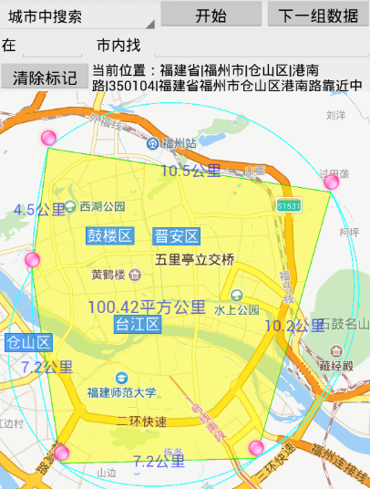
// 下面是在地圖上添加繪圖操作 private static int lineColor = 0x55FF0000; private static int arcColor = 0xbb00FFFF; private static int textColor = 0x990000FF; private static int polygonColor = 0x77FFFF00; private static int radius = 100; private ArrayListposArray = new ArrayList (); boolean is_polygon = false; private void addDot(LatLng pos) { if (is_polygon == true && posArray.size() > 1 && MapUtil.isInsidePolygon(pos, posArray) == true) { Log.d(TAG, "isInsidePolygon"); LatLng centerPos = MapUtil.getCenterPos(posArray); OverlayOptions ooText = new TextOptions().bgColor(0x00ffffff) .fontSize(26).fontColor(textColor).text("標題")// .rotate(-30) .position(centerPos); mMapLayer.addOverlay(ooText); return; } if (is_polygon == true) { Log.d(TAG, "is_polygon == true"); posArray.clear(); is_polygon = false; } boolean is_first = false; LatLng thisPos = pos; if (posArray.size() > 0) { LatLng firstPos = posArray.get(0); int distance = (int) Math.round(MapUtil.getShortDistance( thisPos.longitude, thisPos.latitude, firstPos.longitude, firstPos.latitude)); //多次點擊起點,要忽略之 if (posArray.size()==1 && distance<=0) { return; } else if (posArray.size() > 1) { LatLng lastPos = posArray.get(posArray.size()-1); int lastDistance = (int) Math.round(MapUtil.getShortDistance( thisPos.longitude, thisPos.latitude, lastPos.longitude, lastPos.latitude)); //重復響應當前位置的點擊,要忽略之 if (lastDistance <= 0) { return; } } if (distance < radius * 2) { thisPos = firstPos; is_first = true; } Log.d(TAG, "distance="+distance+", radius="+radius+", is_first="+is_first); // 畫直線 LatLng lastPos = posArray.get(posArray.size() - 1); List points = new ArrayList (); points.add(lastPos); points.add(thisPos); OverlayOptions ooPolyline = new PolylineOptions().width(2) .color(lineColor).points(points); mMapLayer.addOverlay(ooPolyline); // 下面計算兩點之間距離 distance = (int) Math.round(MapUtil.getShortDistance( thisPos.longitude, thisPos.latitude, lastPos.longitude, lastPos.latitude)); String disText = ""; if (distance > 1000) { disText = Math.round(distance * 10 / 1000) / 10d + "公裡"; } else { disText = distance + "米"; } LatLng llText = new LatLng( (thisPos.latitude + lastPos.latitude) / 2, (thisPos.longitude + lastPos.longitude) / 2); OverlayOptions ooText = new TextOptions().bgColor(0x00ffffff) .fontSize(24).fontColor(textColor).text(disText)// .rotate(-30) .position(llText); mMapLayer.addOverlay(ooText); } if (is_first != true) { // 畫圓圈 OverlayOptions ooCircle = new CircleOptions().fillColor(lineColor) .center(thisPos).stroke(new Stroke(2, 0xAAFF0000)).radius(radius); mMapLayer.addOverlay(ooCircle); // 畫圖片標記 BitmapDescriptor bitmapDesc = BitmapDescriptorFactory .fromResource(R.drawable.icon_geo); OverlayOptions ooMarker = new MarkerOptions().draggable(false) .visible(true).icon(bitmapDesc).position(thisPos); mMapLayer.addOverlay(ooMarker); mMapLayer.setOnMarkerClickListener(new OnMarkerClickListener() { @Override public boolean onMarkerClick(Marker marker) { LatLng markPos = marker.getPosition(); addDot(markPos); return true; } }); } else { Log.d(TAG, "posArray.size()="+posArray.size()); //可能存在地圖與標記同時響應點擊事件的情況 if (posArray.size() < 3) { posArray.clear(); is_polygon = false; return; } // 畫多邊形 OverlayOptions ooPolygon = new PolygonOptions().points(posArray) .stroke(new Stroke(1, 0xFF00FF00)) .fillColor(polygonColor); mMapLayer.addOverlay(ooPolygon); is_polygon = true; // 下面計算多邊形的面積 LatLng centerPos = MapUtil.getCenterPos(posArray); double area = Math.round(MapUtil.getArea(posArray)); String areaText = ""; if (area > 1000000) { areaText = Math.round(area * 100 / 1000000) / 100d + "平方公裡"; } else { areaText = (int) area + "平方米"; } OverlayOptions ooText = new TextOptions().bgColor(0x00ffffff) .fontSize(26).fontColor(textColor).text(areaText)// .rotate(-30) .position(centerPos); mMapLayer.addOverlay(ooText); } posArray.add(thisPos); if (posArray.size() >= 3) { // 畫弧線 OverlayOptions ooArc = new ArcOptions() .color(arcColor) .width(2) .points(posArray.get(posArray.size() - 1), posArray.get(posArray.size() - 2), posArray.get(posArray.size() - 3)); mMapLayer.addOverlay(ooArc); } } @Override public void onMapClick(LatLng arg0) { addDot(arg0); } @Override public boolean onMapPoiClick(MapPoi arg0) { addDot(arg0.getPosition()); return false; }
// 下面是在地圖上添加繪圖操作 private static int lineColor = 0x55FF0000; private static int arcColor = 0xbb00FFFF; private static int textColor = 0x990000FF; private static int polygonColor = 0x77FFFF00; private static int radius = 100; private ArrayListposArray = new ArrayList (); boolean is_polygon = false; private void addDot(LatLng pos) { if (is_polygon == true && posArray.size() > 1 && MapUtil.isInsidePolygon(pos, posArray) == true) { Log.d(TAG, "isInsidePolygon"); LatLng centerPos = MapUtil.getCenterPos(posArray); TextOptions ooText = new TextOptions().backgroundColor(0x00ffffff) .fontSize(26).fontColor(textColor).text("標題")// .rotate(-30) .position(centerPos); mMapLayer.addText(ooText); return; } if (is_polygon == true) { Log.d(TAG, "is_polygon == true"); posArray.clear(); is_polygon = false; } boolean is_first = false; LatLng thisPos = pos; if (posArray.size() > 0) { LatLng firstPos = posArray.get(0); int distance = (int) Math.round(MapUtil.getShortDistance( thisPos.longitude, thisPos.latitude, firstPos.longitude, firstPos.latitude)); //多次點擊起點,要忽略之 if (posArray.size()==1 && distance<=0) { return; } else if (posArray.size() > 1) { LatLng lastPos = posArray.get(posArray.size()-1); int lastDistance = (int) Math.round(MapUtil.getShortDistance( thisPos.longitude, thisPos.latitude, lastPos.longitude, lastPos.latitude)); //重復響應當前位置的點擊,要忽略之 if (lastDistance <= 0) { return; } } if (distance < radius * 2) { thisPos = firstPos; is_first = true; } Log.d(TAG, "distance="+distance+", radius="+radius+", is_first="+is_first); // 畫直線 LatLng lastPos = posArray.get(posArray.size() - 1); List points = new ArrayList (); points.add(lastPos); points.add(thisPos); PolylineOptions ooPolyline = new PolylineOptions().width(2) .color(lineColor).addAll(points); mMapLayer.addPolyline(ooPolyline); // 下面計算兩點之間距離 distance = (int) Math.round(MapUtil.getShortDistance( thisPos.longitude, thisPos.latitude, lastPos.longitude, lastPos.latitude)); String disText = ""; if (distance > 1000) { disText = Math.round(distance * 10 / 1000) / 10d + "公裡"; } else { disText = distance + "米"; } LatLng llText = new LatLng( (thisPos.latitude + lastPos.latitude) / 2, (thisPos.longitude + lastPos.longitude) / 2); TextOptions ooText = new TextOptions().backgroundColor(0x00ffffff) .fontSize(24).fontColor(textColor).text(disText)// .rotate(-30) .position(llText); mMapLayer.addText(ooText); } if (is_first != true) { // 畫圓圈 CircleOptions ooCircle = new CircleOptions().fillColor(lineColor) .center(thisPos).strokeWidth(2).strokeColor(0xAAFF0000).radius(radius); mMapLayer.addCircle(ooCircle); // 畫圖片標記 BitmapDescriptor bitmapDesc = BitmapDescriptorFactory .fromResource(R.drawable.icon_geo); MarkerOptions ooMarker = new MarkerOptions().draggable(false) .visible(true).icon(bitmapDesc).position(thisPos); mMapLayer.addMarker(ooMarker); mMapLayer.setOnMarkerClickListener(new OnMarkerClickListener() { @Override public boolean onMarkerClick(Marker marker) { LatLng markPos = marker.getPosition(); addDot(markPos); marker.showInfoWindow(); return true; } }); } else { Log.d(TAG, "posArray.size()="+posArray.size()); //可能存在地圖與標記同時響應點擊事件的情況 if (posArray.size() < 3) { posArray.clear(); is_polygon = false; return; } // 畫多邊形 PolygonOptions ooPolygon = new PolygonOptions().addAll(posArray) .strokeColor(0xFF00FF00).strokeWidth(1) .fillColor(polygonColor); mMapLayer.addPolygon(ooPolygon); is_polygon = true; // 下面計算多邊形的面積 LatLng centerPos = MapUtil.getCenterPos(posArray); double area = Math.round(MapUtil.getArea(posArray)); String areaText = ""; if (area > 1000000) { areaText = Math.round(area * 100 / 1000000) / 100d + "平方公裡"; } else { areaText = (int) area + "平方米"; } TextOptions ooText = new TextOptions().backgroundColor(0x00ffffff) .fontSize(26).fontColor(textColor).text(areaText)// .rotate(-30) .position(centerPos); mMapLayer.addText(ooText); } posArray.add(thisPos); if (posArray.size() >= 3) { // 畫弧線 ArcOptions ooArc = new ArcOptions() .strokeColor(arcColor) .strokeWidth(2) .point(posArray.get(posArray.size() - 1), posArray.get(posArray.size() - 2), posArray.get(posArray.size() - 3)); mMapLayer.addArc(ooArc); } } @Override public void onMapClick(LatLng arg0) { addDot(arg0); }
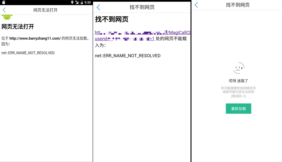 【Android】WebView:onReceiveError的應用與變遷
onReceiveError是WebViewClient提供的方法,用於網頁產生錯誤時進行回調處理。1. 舊版的onReceiveError在API23之前,該方法的簽名
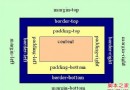 android LinearLayout和RelativeLayout組合實現精確布局方法介紹
先明確幾個概念的區別: padding margin都是邊距的含義,關鍵問題得明白是什麼相對什麼的邊距. padding是控件的內容相對控件的邊緣的邊距. margin是
 Android實現可播放GIF動畫的ImageView
Android的原生控件並不支持播放GIF格式的圖片。我們都知道,在Android中如果想要顯示一張圖片,可以借助ImageView來完成,但是如果將一張GIF圖片設置到
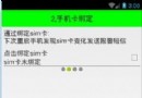 Android手機衛士之綁定sim卡序列號
現在開始具體 處理每一個導航頁面的邏輯,首先看第二個導航頁這裡需要實現綁定sim卡序列號的功能,注意添加相應的權限:uses-permission android:nam